
Vegetation Change and farmland Concentration Within Grazing Reserves in Adamawa State, Nigeria
DOI:
https://doi.org/10.33003/fjs-2026-1023-6245Keywords:
NDVI, grazing reserves, farmland concentration, seasonal vegetation, Adamawa, remote sensingAbstract
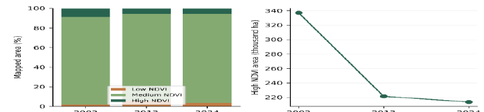
Vegetation monitoring can inform pastoral land management only when changes in greenness, seasonal vegetation and mapped cultivation are distinguished. This study reanalysed Landsat-derived vegetation summaries for 2002, 2013 and 2024, five Sentinel-2 monthly vegetation summaries for 2024, and land-cover statistics for ten grazing reserves in Adamawa State, Nigeria. Relative change, annualised loss, loss-to-gain ratios, area-weighted farmland prevalence, concentration and deterministic classification-error scenarios were calculated. High-NDVI cover declined from 337,020.66 to 213,629.85 ha, a 36.61% reduction rather than the previously reported 50%. About 93.76% of this net loss occurred during 2002–2013. Within the pairwise change domain, decreases exceeded increases by 19.57 times over 2002–2024. The ten reserves contained 6,446.07 ha of mapped farmland, equivalent to 17.76% of their reported combined area. Dauchi, Guyaku and Ladde Dan-Kiffi accounted for 61.07% of mapped reserve farmland while occupying 44.26% of assessed reserve area. A conditional reserve-level permutation test found limited size–prevalence association (rho = 0.406; p = 0.248), while concentration equalled 5.78 equally contributing reserves. Monthly vegetation presence ranged from 20.19% in May to 96.74% in November. However, mismatches between pixel counts, area conversion and land-cover summaries prevent the seasonal classification from being treated as an independently validated cultivation map. The results support targeted verification of concentrated cultivation and monitoring of high-NDVI loss, while demonstrating why greenness change alone cannot establish deforestation, unlawful encroachment or conflict causation
References
Belgiu, M., & Csillik, O. (2018). Sentinel-2 cropland mapping using pixel-based and object-based time-weighted dynamic time warping analysis. Remote Sensing of Environment, 204, 509–523. https://doi.org/10.1016/j.rse.2017.10.005
Claverie, M., Ju, J., Masek, J. G., Dungan, J. L., Vermote, E. F., Roger, J. C., Skakun, S. V., & Justice, C. (2018). The Harmonized Landsat and Sentinel-2 surface reflectance data set. Remote Sensing of Environment, 219, 145–161. https://doi.org/10.1016/j.rse.2018.09.002
Congalton, R. G. (1991). A review of assessing the accuracy of classifications of remotely sensed data. Remote Sensing of Environment, 37(1), 35–46. https://doi.org/10.1016/0034-4257(91)90048-b
Dardel, C., Kergoat, L., Hiernaux, P., Mougin, E., Grippa, M., & Tucker, C. J. (2014). Re-greening Sahel: 30 years of remote sensing data and field observations (Mali, Niger). Remote Sensing of Environment, 140, 350–364. https://doi.org/10.1016/j.rse.2013.09.011
Drusch, M., Del Bello, U., Carlier, S., Colin, O., Fernandez, V., Gascon, F., Hoersch, B., Isola, C., Laberinti, P., Martimort, P., Meygret, A., Spoto, F., Sy, O., Marchese, F., & Bargellini, P. (2012). Sentinel-2: ESA's optical high-resolution mission for GMES operational services. Remote Sensing of Environment, 120, 25–36. https://doi.org/10.1016/j.rse.2011.11.026
Fensholt, R., Langanke, T., Rasmussen, K., Reenberg, A., Prince, S. D., Tucker, C., Scholes, R. J., Le, Q. B., Bondeau, A., Eastman, R., Epstein, H., Gaughan, A. E., Hellden, U., Mbow, C., Olsson, L., Paruelo, J., Schweitzer, C., Seaquist, J., & Wessels, K. (2012). Greenness in semi-arid areas across the globe 1981–2007 — an Earth Observing Satellite based analysis of trends and drivers. Remote Sensing of Environment, 121, 144–158. https://doi.org/10.1016/j.rse.2012.01.017
Foody, G. M. (2002). Status of land cover classification accuracy assessment. Remote Sensing of Environment, 80(1), 185–201. https://doi.org/10.1016/s0034-4257(01)00295-4
Gailyson, N. J., Ubogu, A. E., & Abdu, Y. (2026). Land use/land cover dynamics and the decline of grazing resources in Dauchi Grazing Reserve, Adamawa State, Nigeria. FUDMA Journal of Sciences, 10(18), 271–276. https://doi.org/10.33003/fjs-2026-1018-6083
Gorelick, N., Hancher, M., Dixon, M., Ilyushchenko, S., Thau, D., & Moore, R. (2017). Google Earth Engine: Planetary-scale geospatial analysis for everyone. Remote Sensing of Environment, 202, 18–27. https://doi.org/10.1016/j.rse.2017.06.031
Herrmann, S. M., Anyamba, A., & Tucker, C. J. (2005). Recent trends in vegetation dynamics in the African Sahel and their relationship to climate. Global Environmental Change, 15(4), 394–404. https://doi.org/10.1016/j.gloenvcha.2005.08.004
Huang, S., Tang, L., Hupy, J. P., Wang, Y., & Shao, G. (2021). A commentary review on the use of normalized difference vegetation index (NDVI) in the era of popular remote sensing. Journal of Forestry Research, 32(1), 1–6. https://doi.org/10.1007/s11676-020-01155-1
Huete, A. R. (1988). A soil-adjusted vegetation index (SAVI). Remote Sensing of Environment, 25(3), 295–309. https://doi.org/10.1016/0034-4257(88)90106-x
Hurlbert, S. H. (1984). Pseudoreplication and the design of ecological field experiments. Ecological Monographs, 54(2), 187–211. https://doi.org/10.2307/1942661
Ibrahim, E. S., Rufin, P., Nill, L., Kamali, B., Nendel, C., & Hostert, P. (2021). Mapping crop types and cropping systems in Nigeria with Sentinel-2 imagery. Remote Sensing, 13(17), Article 3523. https://doi.org/10.3390/rs13173523
Jost, L. (2006). Entropy and diversity. Oikos, 113(2), 363–375. https://doi.org/10.1111/j.2006.0030-1299.14714.x
Kennedy, R. E., Yang, Z., & Cohen, W. B. (2010). Detecting trends in forest disturbance and recovery using yearly Landsat time series: 1. LandTrendr — Temporal segmentation algorithms. Remote Sensing of Environment, 114(12), 2897–2910. https://doi.org/10.1016/j.rse.2010.07.008
Mbow, C., Brandt, M., Ouedraogo, I., De Leeuw, J., & Marshall, M. (2015). What four decades of earth observation tell us about land degradation in the Sahel?. Remote Sensing, 7(4), 4048–4067. https://doi.org/10.3390/rs70404048
Olofsson, P., Foody, G. M., Herold, M., Stehman, S. V., Woodcock, C. E., & Wulder, M. A. (2014). Good practices for estimating area and assessing accuracy of land change. Remote Sensing of Environment, 148, 42–57. https://doi.org/10.1016/j.rse.2014.02.015
Pettorelli, N., Vik, J. O., Mysterud, A., Gaillard, J. M., Tucker, C. J., & Stenseth, N. C. (2005). Using the satellite-derived NDVI to assess ecological responses to environmental change. Trends in Ecology & Evolution, 20(9), 503–510. https://doi.org/10.1016/j.tree.2005.05.011
Phipson, B., & Smyth, G. K. (2010). Permutation P-values should never be zero: Calculating exact P-values when permutations are randomly drawn. Statistical Applications in Genetics and Molecular Biology, 9(1), Article 39. https://doi.org/10.2202/1544-6115.1585
Pontius, R. G., & Millones, M. (2011). Death to Kappa: Birth of quantity disagreement and allocation disagreement for accuracy assessment. International Journal of Remote Sensing, 32(15), 4407–4429. https://doi.org/10.1080/01431161.2011.552923
Reid, R. S., Fernández-Giménez, M. E., & Galvin, K. A. (2014). Dynamics and resilience of rangelands and pastoral peoples around the globe. Annual Review of Environment and Resources, 39(1), 217–242. https://doi.org/10.1146/annurev-environ-020713-163329
Roy, D. P., Kovalskyy, V., Zhang, H. K., Vermote, E. F., Yan, L., Kumar, S. S., & Egorov, A. (2016). Characterization of Landsat-7 to Landsat-8 reflective wavelength and normalized difference vegetation index continuity. Remote Sensing of Environment, 185, 57–70. https://doi.org/10.1016/j.rse.2015.12.024
Sarkinzango, I. (2026). Developing a sustainable geospatial model for co-habitation between farmers and herders in Adamawa State [Unpublished doctoral thesis manuscript]. Modibbo Adama University.
Song, X. P., Hansen, M. C., Stehman, S. V., Potapov, P. V., Tyukavina, A., Vermote, E. F., & Townshend, J. R. (2018). Global land change from 1982 to 2016. Nature, 560(7720), 639–643. https://doi.org/10.1038/s41586-018-0411-9
Souverijns, N., Buchhorn, M., Horion, S., Fensholt, R., Verbeeck, H., Verbesselt, J., Herold, M., Tsendbazar, N. E., Bernardino, P. N., Somers, B., & Van De Kerchove, R. (2020). Thirty years of land cover and fraction cover changes over the Sudano-Sahel using Landsat time series. Remote Sensing, 12(22), Article 3817. https://doi.org/10.3390/rs12223817
Spearman, C. (1904). The proof and measurement of association between two things. The American Journal of Psychology, 15(1), 72–101. https://doi.org/10.2307/1412159
Stehman, S. V., & Foody, G. M. (2019). Key issues in rigorous accuracy assessment of land cover products. Remote Sensing of Environment, 231, Article 111199. https://doi.org/10.1016/j.rse.2019.05.018
Tucker, C. J. (1979). Red and photographic infrared linear combinations for monitoring vegetation. Remote Sensing of Environment, 8(2), 127–150. https://doi.org/10.1016/0034-4257(79)90013-0
Turner, M. D., & Schlecht, E. (2019). Livestock mobility in sub-Saharan Africa: A critical review. Pastoralism, 9(1), Article 13. https://doi.org/10.1186/s13570-019-0150-z
U.S. Geological Survey. (n.d.). What are the band designations for the Landsat satellites? https://www.usgs.gov/faqs/what-are-band-designations-landsat-satellites
Verbesselt, J., Hyndman, R., Newnham, G., & Culvenor, D. (2010). Detecting trend and seasonal changes in satellite image time series. Remote Sensing of Environment, 114(1), 106–115. https://doi.org/10.1016/j.rse.2009.08.014
Wasserstein, R. L., & Lazar, N. A. (2016). The ASA statement on p-values: Context, process, and purpose. The American Statistician, 70(2), 129–133. https://doi.org/10.1080/00031305.2016.1154108
Winkler, K., Fuchs, R., Rounsevell, M., & Herold, M. (2021). Global land use changes are four times greater than previously estimated. Nature Communications, 12(1), Article 2501. https://doi.org/10.1038/s41467-021-22702-2
Wulder, M. A., Loveland, T. R., Roy, D. P., Crawford, C. J., Masek, J. G., Woodcock, C. E., Allen, R. G., Anderson, M. C., Belward, A. S., Cohen, W. B., Dwyer, J., Erb, A., Gao, F., Griffiths, P., Helder, D., Hermosilla, T., Hipple, J. D., Hostert, P., Hughes, M. J., … Zhu, Z. (2019). Current status of Landsat program, science, and applications. Remote Sensing of Environment, 225, 127–147. https://doi.org/10.1016/j.rse.2019.02.015
Xue, J., & Su, B. (2017). Significant remote sensing vegetation indices: A review of developments and applications. Journal of Sensors, 2017, Article 1353691. https://doi.org/10.1155/2017/1353691
Zeng, Y., Hao, D., Huete, A., Dechant, B., Berry, J., Chen, J. M., Joiner, J., Frankenberg, C., Bond-Lamberty, B., Ryu, Y., Xiao, J., Asrar, G. R., & Chen, M. (2022). Optical vegetation indices for monitoring terrestrial ecosystems globally. Nature Reviews Earth & Environment, 3(7), 477–493. https://doi.org/10.1038/s43017-022-00298-5
Zhu, Z., & Woodcock, C. E. (2012). Object-based cloud and cloud shadow detection in Landsat imagery. Remote Sensing of Environment, 118, 83–94. https://doi.org/10.1016/j.rse.2011.10.028
Zhu, Z., & Woodcock, C. E. (2014). Continuous change detection and classification of land cover using all available Landsat data. Remote Sensing of Environment, 144, 152–171. https://doi.org/10.1016/j.rse.2014.01.011
Zhu, Z., Wang, S., & Woodcock, C. E. (2015). Improvement and expansion of the Fmask algorithm: Cloud, cloud shadow, and snow detection for Landsats 4–7, 8, and Sentinel 2 images. Remote Sensing of Environment, 159, 269–277. https://doi.org/10.1016/j.rse.2014.12.014
Downloads
Published
Issue
Section
Categories
License
Copyright (c) 2026 Isa Sarkinzango, Abubakar Akinyele Musa, Takana Abubakar

This work is licensed under a Creative Commons Attribution 4.0 International License.