Field-Based Biomass and Carbon Stock Estimation and Landsat-Derived Spatial Patterns in Tula Highland, Gombe State, Nigeria
DOI:
https://doi.org/10.33003/fjs-2026-1024-6338Keywords:
Aboveground Biomass, Belowground Biomass, Carbon Stock, Landsat 8, Vegetation Indices, Tula HighlandAbstract
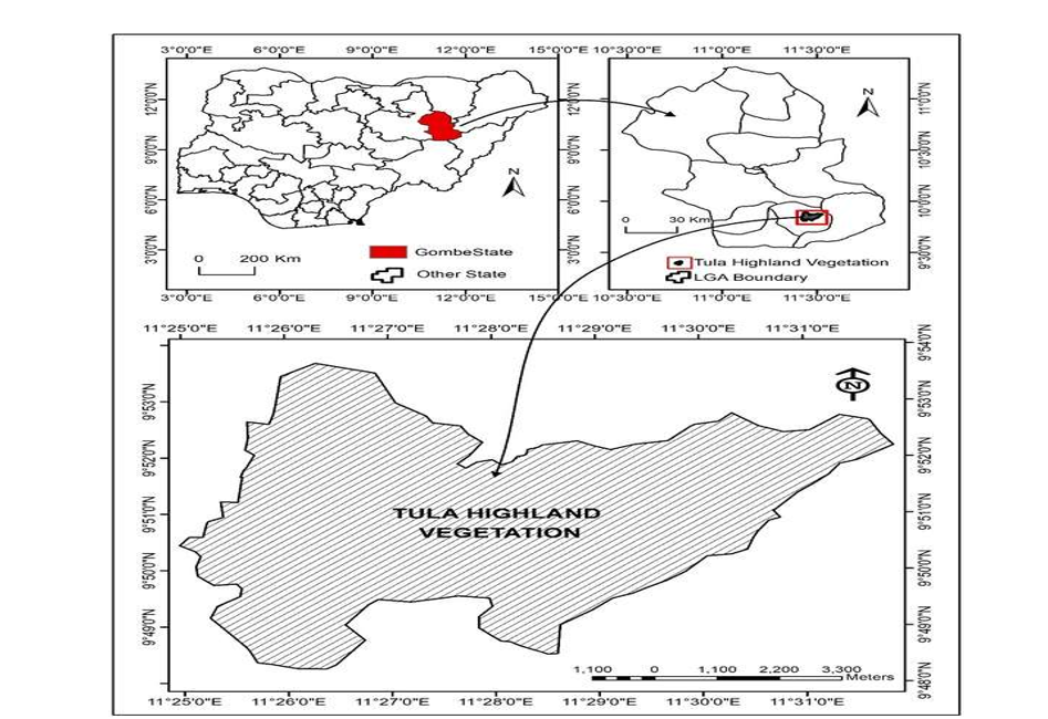
Highland vegetation is poorly represented in Nigeria’s carbon accounting. We estimated aboveground (AGB) and belowground biomass (BGB) and biomass carbon stocks in Tula Highland, Gombe State, and examined their relationship with Landsat-derived vegetation indices. Woody vegetation was inventoried in 13 one-hectare plots, spaced 1 km apart, between February and June 2025. AGB was estimated with allometric equations, BGB with a fixed root-to-shoot ratio of 0.26, and carbon with a fraction of 0.47; litter was reported separately. Landsat 8 OLI imagery for 2020–2024 was used to compute NDVI, SAVI and ARVI. Mean densities were 23.55 Mg ha⁻¹ for AGB (95% CI 10.27–36.82) and 6.12 Mg ha⁻¹ for BGB, a combined 29.67 Mg ha⁻¹ (13.95 Mg C ha⁻¹), with large variation among plots (0.18–108.62 Mg ha⁻¹). Summed over the plots, AGB and BGB were 306.14 and 79.60 Mg (181.29 Mg C). Because BGB is a fixed fraction of AGB, it carries no independent information; a ratio of 0.56 would raise mean total biomass to 36.74 Mg ha⁻¹. A three-index linear model gave an adjusted R² of 0.986 (AIC = 173.93) for the calibration plots, but the small sample, near-collinear indices and lack of independent validation limit confidence in spatial predictions. Model-derived mean AGB rose by 16.99% between 2020 and 2024; this reflects spectral change, not measured biomass accumulation or carbon sequestration. The results are a preliminary baseline and show the need for more plots, repeated inventories and formal uncertainty assessment.
References
Ajayi, O. L. P. (2026). Operationalisation of the Nigerian carbon market. Olaniwun Ajayi Insights. https://www.olaniwunajayi.net/blog/operationalisation-of-the-nigerian-carbon-market/
Asrat, Z., Taddese, H., Ørka, H. O., Gobakken, T., Burud, I., & Næsset, E. (2018). Estimation of forest area and canopy cover based on visual interpretation of satellite images in Ethiopia. Land, 7(3), Article 92.
Biah, I., Azihou, A. F., Guendehou, S., & Sinsin, B. (2024). Land use/land cover change and carbon footprint in tropical ecosystems in Benin, West Africa. Trees, Forests and People, 15, Article 100488.
Bordoloi, R., Das, B., Tripathi, O. P., Sahoo, U. K., Nath, A. J., Deb, S., Devi, N. B., & Gupta, A. (2021). Satellite data derived spatiotemporal variation of biomass carbon stocks and their relation with vegetation type in tropical forests of Assam in northeast India. Ecological Indicators, 123, Article 107341. https://doi.org/10.1016/j.ecolind.2021.107341
Bos, A. B., De Sy, V., Duchelle, A. E., Herold, M., & Martius, C. (2019). Global data and tools for local forest cover loss and REDD+ performance assessment: Gaps, needs and possible approaches. Environmental Science & Policy, 92, 357–367.
Burnham, K. P., & Anderson, D. R. (2002). Model selection and multimodel inference: A practical information-theoretic approach (2nd ed.). Springer.
Chabi, A., Lautenbach, S., Tondoh, J. E., Orekan, V. O. A., Kyei-Baffour, N., & Blaes, X. (2016). The relevance of using in situ carbon stocks and satellite indices to assess aboveground carbon stock of tropical forest ecosystems. iForest, 9, 606–615.
Chave, J., Condit, R., Aguilar, S., Hernandez, A., Lao, S., & Perez, R. (2004). Error propagation and scaling for tropical forest biomass estimates. Philosophical Transactions of the Royal Society B: Biological Sciences, 359(1443), 409–420.
Chave, J., Réjou-Méchain, M., Búrquez, A., Chidumayo, E., Colgan, M. S., Delitti, W. B. C., Duque, A., Eid, T., Fearnside, P. M., Goodman, R. C., Henry, M., Martínez-Yrízar, A., Mugasha, W. A., Muller-Landau, H. C., Mencuccini, M., Nelson, B. W., Ngomanda, A., Nogueira, E. M., Ortiz-Malavassi, E., Vieilledent, G. (2014). Improved allometric models to estimate the aboveground biomass of tropical trees. Global Change Biology, 20(10), 3177–3190. https://doi.org/10.1111/gcb.12629
Chen, C., He, G., Fang, H., Shi, L., Zhuang, Y., Ding, Z., Guo, J., Yue, X., Yang, K., & Xi, W. (2025). A study on the remote sensing estimation and spatiotemporal distribution patterns of aboveground biomass in savanna grasslands of the Yuanmou dry-hot valley. Frontiers in Plant Science, 16, Article 1648539.
Conti, G., Enrico, L., Casanoves, F., & Díaz, S. (2019). Shrub biomass estimation in the semiarid Chaco forest: A contribution to the understanding of South American dryland carbon sinks. Journal of Arid Environments, 166, 51–60.
Global Climate Observing System. (2016). The global observing system for climate: Implementation needs (GCOS-200). World Meteorological Organization.
Henry, M., Tittonell, P., Manlay, R. J., Bernoux, M., Albrecht, A., & Vanlauwe, B. (2009). Biodiversity, carbon stocks and sequestration potential in aboveground biomass in smallholder farming systems of western Kenya. Agriculture, Ecosystems & Environment, 129(1–3), 238–252. https://doi.org/10.1016/j.agee.2008.09.006
Herold, M., Carter, S., Avitabile, V., Espejo, A. B., Jonckheere, I., Lucas, R., McRoberts, R. E., Næsset, E., Nightingale, J., Petersen, R., Reiche, J., Romijn, E., Rosenqvist, Å., Rozendaal, D. M. A., Seifert, F. M., Sanz, M. J., & De Sy, V. (2019). The role and need for space-based forest biomass-related measurements in environmental management and policy. Surveys in Geophysics, 40, 757–778. https://doi.org/10.1007/s10712-019-09510-6
Huete, A. R. (1988). A soil-adjusted vegetation index (SAVI). Remote Sensing of Environment, 25(3), 295–309. https://doi.org/10.1016/0034-4257(88)90106-X
Intergovernmental Panel on Climate Change. (2006). 2006 IPCC guidelines for national greenhouse gas inventories (H. S. Eggleston, L. Buendia, K. Miwa, T. Ngara, & K. Tanabe, Eds.). Institute for Global Environmental Strategies.
Intergovernmental Panel on Climate Change. (2019). 2019 refinement to the 2006 IPCC guidelines for national greenhouse gas inventories (E. Calvo Buendia, K. Tanabe, A. Kranjc, J. Baasansuren, M. Fukuda, S. Ngarize, A. Osako, Y. Pyrozhenko, P. Shermanau, & S. Federici, Eds.). IPCC.
Jimoh, A. I., Hussaini, H., Aliyu, J., Sadiq, F. K., & Kefas, P. K. (2022). Assessment of the impacts of toposequence on soil properties and quality in Tula, Gombe State, Nigeria. Agricultura Tropica et Subtropica, 55(1), 99–107.
Kaufman, Y. J., & Tanré, D. (1992). Atmospherically resistant vegetation index (ARVI) for EOS-MODIS. IEEE Transactions on Geoscience and Remote Sensing, 30(2), 261–270. https://doi.org/10.1109/36.134076
Kumar, L., & Mutanga, O. (2017). Remote sensing of above-ground biomass. Remote Sensing, 9(9), Article 935. https://doi.org/10.3390/rs9090935
Ma, H., Mo, L., Crowther, T. W., Maynard, D. S., van den Hoogen, J., Stocker, B. D., Terrer, C., & Zohner, C. M. (2021). The global distribution and environmental drivers of aboveground versus belowground plant biomass. Nature Ecology & Evolution, 5, 1110–1122. https://doi.org/10.1038/s41559-021-01485-1
Mokany, K., Raison, R. J., & Prokushkin, A. S. (2006). Critical analysis of root:shoot ratios in terrestrial biomes. Global Change Biology, 12(1), 84–96. https://doi.org/10.1111/j.1365-2486.2005.001043.x
Muhammad, B., Rehman, A. U., Mumtaz, F., Qun, Y., & Zhongkui, J. (2024). Estimation of above-ground biomass in dry temperate forests using Sentinel-2 data and random forest: A case study of the Swat area of Pakistan. Frontiers in Environmental Science, 12, Article 1448648.
Poudel, A., Shrestha, H. L., Mahat, N., Sharma, G., Aryal, S., Kalakheti, R., & Lamsal, B. (2023). Modeling and mapping of aboveground biomass and carbon stock using Sentinel-2 imagery in Chure region, Nepal. International Journal of Forestry Research, 2023, Article 5553957.
PwC. (2023). Nigeria’s Climate Change Act: Implications for business and investment. PricewaterhouseCoopers Nigeria.
Ravindranath, N. H., & Ostwald, M. (2008). Carbon inventory methods: Handbook for greenhouse gas inventory, carbon mitigation and roundwood production projects. Springer.
Rouse, J. W., Haas, R. H., Schell, J. A., & Deering, D. W. (1974). Monitoring vegetation systems in the Great Plains with ERTS. In Proceedings of the Third Earth Resources Technology Satellite-1 Symposium (Vol. 1, pp. 309–317). NASA.
Rügnitz, M. T., Chacón, M. L., & Porro, R. (2009). Guía para la determinación de carbono en pequeñas propiedades rurales. ICRAF.
Temesgen, H., Affleck, D., Poudel, K., Gray, A., & Sessions, J. (2015). A review of the challenges and opportunities in estimating above ground forest biomass using tree-level models. Scandinavian Journal of Forest Research, 30(4), 326–335.
Tomlin, C. D. (1990). Geographic information systems and cartographic modeling. Prentice Hall.
Tucker, C. J. (1979). Red and photographic infrared linear combinations for monitoring vegetation. Remote Sensing of Environment, 8(2), 127–150. https://doi.org/10.1016/0034-4257(79)90013-0
Wang, M., Ciais, P., Fensholt, R., Brandt, M., Tao, S., Li, W., Fan, L., Frappart, F., Sun, R., Li, X., Liu, X., Wang, H., Cui, T., Xing, Z., Zhao, Z., & Wigneron, J.-P. (2024). Satellite observed aboveground carbon dynamics in Africa during 2003–2021. Remote Sensing of Environment, 301, Article 113927.
Yanai, R. D., Battles, J. J., Richardson, A. D., Blodgett, C. A., Wood, D. M., & Rastetter, E. B. (2010). Estimating uncertainty in ecosystem budget calculations. Ecosystems, 13, 239–248.
Yilangai, R. M., Abalaka, J., Nsor, C. A., Babale, A., Karau, S. D., & Ivande, S. (2023). Effect of disturbance on bird feeding guilds in a West African dry forest. African Journal of Ecology, 61(2), 461–468.
Yuguda, U. A., Saka, M. G., Dishan, E. E., Abba, H. M., & Bello, M. B. (2026). Spatial patterns and temporal dynamics of aboveground-belowground biomass and carbon stocks in Kanawa Forest Reserve, Gombe State, Nigeria. Bima Journal of Science and Technology, 10(3). https://doi.org/10.64290/bima.v10i3.1651
Zhang, Y., Liang, S., & Yang, L. (2019). A review of regional and global gridded forest biomass datasets. Remote Sensing, 11(23), Article 2744.
Downloads
Published
Issue
Section
Categories
License
Copyright (c) 2026 Usman Abubakar Yuguda, Moruff Gbolagade Saka, Ephraim Edward Dishan

This work is licensed under a Creative Commons Attribution 4.0 International License.