
Determination of Optimal Routes to Markets for Efficient fire Emergency Services in Gombe Metropolis, Gombe State, Nigeria
DOI:
https://doi.org/10.33003/Keywords:
GIS, Fire, Emergency Services, Markets, Optimal Routes, Gombe MetropolisAbstract
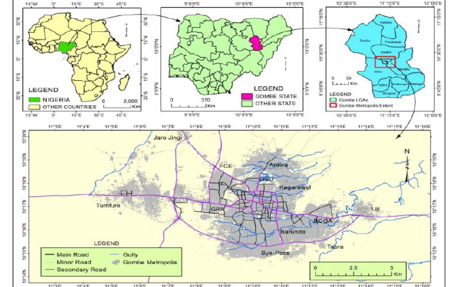
Firefighting performance can be represented by the speed of handling the fire case, which is greatly influenced by the travel speed of the fire trucks to the fire location. This paper aims to determine the optimal routes to markets using remote sensing and GIS techniques for efficient fire emergency services to reduce time wasted in delivering services to fire victims in Gombe metropolis. It is observed that very often, the response of the fire service to distress calls for their intervention following fire outbreaks is well below the required standards. They arrive when significant damages have been done, thus, compromising their efficiency. In this paper, Google earth satellite imagery of the study area was downloaded, coordinates of fire emergency service and markets was obtained using handheld GPS (Garmin Oregon 550). Arc GIS network analysis extension tools was used for the generation of network geo-dataset and to measure the efficiency of services in terms of travel time. The study identified two (2) fire service stations (Tashan Dukku fire service and main market fire service) and twenty-four (24) markets. The study concludes that GIS-based network analysis is indispensable for identifying optimal emergency routes, and that the current spatial distribution of fire stations is inadequate for timely market coverage. The study recommends the use of real time imagery by creating an application, improvement in road networks in the study area, population distribution should also be a considerable factor in citing fire service stations in future as means for achieving better safety situations
References
Abashiya M, Abaje I. B, Musa I, Sule S, Kollos P. N and Garba H. A. (2019). Hydrogeomorphic Characteristics of Urban Flood Triggers in Gombe Town, Nigeria as Monitored in 2014. Journal of Application Science and Environmental Management. 23 (10) 1887-1892.
Arowolo T.A, Adekunle A, Omojola O. Olumide and Ibrahim H.D (2020). Structural Fire Analysis in Residential and Commercial Buildings Based on Ignition Frequency, Fire Extinguisher Performance, and Fire Risk Indexes in the South-East Zone of Nigeria from 2010 to 2019. IJAAR, 6, (10), 35-73.
Adekunle A. Umanah I. I, Ibe K. E, and Imonikosaye M.R (2018). Statistical Analysis of Fire Outbreaks in Homes and Public Buildings in Nigeria: A Case Study of Lagos State. International Journal of Engineering Research and Advanced Technology (IJERAT). 4, 21-30.
Agbonkhese O, Yerima A. B, Ladkiwa A. Y and Kawu Y, (2017). Curbing Menace of Urban Fire Outbreak in Residential Buildings: A Case Study of Gombe Metropolis. Scientific Research Journal (SCIRJ), 5, 49-63.
Amos B. B, Musa I, Abashiya M. and Abaje I. B. (2015). Impact of Cement Dust Emissions on Soils within 10km Radius in Ashaka area, Gombe State, Nigeria. International Journal of Environment and Pollution, 4 (1) 0909-0917.
Arowolo T. A, Adewale A. K and Owolabi O. S. (2021). Integration of Fire Safety Performance in Market Design; Case Study of Abubakar Rimi Market, Kano State, Nigeria. International Journal of Advanced Academic Research. 7, 76-86.
Dauda W. A and Lawali R, (2014). Gombe Metropolis Road Network Mapping – An Integrated Approach. Academic Journal of Interdisciplinary Studies. 3, 102-107.
Forkuo E. K and Quaye-Ballard J. A, (2013). GIS Based Fire Emergency Response System. International Journal of Remote Sensing and GIS, 2, 32-40.
Gombe State Economic Empowerment and Development Strategy [GOSEEDS] (2007). Handbook, Abuja, Dandafid Nig. Ltd.
Gombe State Government [G.S.G] (2015). Profile. Retrieved on 14/05/2023; from: http://www.tiptopglobe.com/cities-nigeria?region=55&n=Gombe&a=G.
Isa U. F, Liman M. A, Mohammed M. U, Mathew O. S and Yayo Y. R (2016). Spatial Analysis of Fire Service Station in Kano Metropolis, Nigeria. Journal of Humanities and Social Science (JHSS), 21, 42-52.
Mbaya L. A, Abu G. O, Makadi Y. C and Umar D. M (2019). Impact of Urbanization on Vegetation Cover in Gombe Metropolis and Environs. British Journal of Earth Sciences Research, 4, 17-25.
Ngugi, G.P. (2015). Urban Retail Market Transformation: A Case of Gikomba Market, Nairobi, Kenya. A Thesis Write-up, Department of Architecture and Building Science, School of Built Environment, University of Nairobi. Pp. 13-42.
Ritesh R. K, (2013). Road Network Analysis Using Geoinformatics Technique for Akola City, Maharashtra State, India. International Journal of Engineering Research & Technology (IJERT), 5, 15-26.
Sulaiman Y. (2021). Spatio-Temporal Analysis of Fire Outbreaks in Markets of Kano Metropolis, Kano State, Nigeria. AFRIGIST Journal of Land Administration and Environmental Management, 1, 1-18.
Umar Y. A, Abubakar A, Adam M. A. and Bibi U. M, (2020). Population and Spatial Analysis of Fire Service Provision in Gombe Town. Global Science Journals. 8, 209-223.
Umar Y.A, Yila Caiaphas M and Bello M. B, (2019). Assessment of Socioeconomic Effects and Causes of Fire Outbreaks in Gombe Metropolis. Gombe Journal of Geography and Environmental Studies (GOJGES), 1, 109-120.
Vaishali M, (2019). Optimum route planning of a city using GIS technology. Journal of Emerging Technologies and Innovative Research (JETIR), 6, 402-412
Downloads
Published
Issue
Section
Categories
License
Copyright (c) 2026 Ali Usman, Peter Tizhe

This work is licensed under a Creative Commons Attribution 4.0 International License.